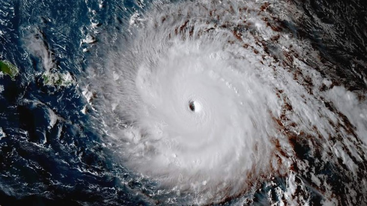
La NASA compartió imágenes de la Estación Espacial Internacional de este pasado martes 5 de septiembre del paso de Irma por el Océano Atlántico.
Irma llegó a categoría 5, uno de los más poderosos huracanes del siglo, y amenaza a Puerto Rico, las Islas Vírgenes y Florida.
La Estación Espacial Internacional mostró una “dramática toma”, según califican en Twitter, de este gran huracán que cubre una notoria parte de la Tierra con su gran manto blanco de nubes.
The International Space Station’s external cameras captured a dramatic view of Hurricane Irma as it moved across the Atlantic Ocean Sept. 5. pic.twitter.com/mc61pt2G8O
— Intl. Space Station (@Space_Station) 5 de septiembre de 2017
Late afternoon sun casting a shadow on Hurricane #Irma‘s eye. #GOES16 pic.twitter.com/CQaSgHzVN6
— NASA SPoRT (@NASA_SPoRT) 5 de septiembre de 2017
Hurricane #Irma now taking aim on the Virgin Islands. Maximum sustained winds remain at 185 MPH. #GOES16 pic.twitter.com/inc4PPxRBz
— NASA SPoRT (@NASA_SPoRT) 6 de septiembre de 2017
An overview of the active tropics: 24-hour animation of TS #Katia (left), Hurricane #Irma (center), and TS #Jose (right). #GOES16 pic.twitter.com/DiuhZP4f6y
— NASA SPoRT (@NASA_SPoRT) 6 de septiembre de 2017
Hurricane #Irma is maintaining it’s strength with maximum sustained winds of 185 MPH. The eye is approaching the island of Barbuda. #GOES16 pic.twitter.com/85fHMLVr5H
— NASA SPoRT (@NASA_SPoRT) 6 de septiembre de 2017


